SABONET
In 1996 a permanent seismic network, the SApanca BOlu NETwork (SABONET) was deployed to investigate the seismic activity at the Karadere- and Düzce Fault east of the Sea of Marmara. This region currently represents the eastern end of a westward migrating earthquake sequence starting in 1939 in eastern Turkey.
The SABOnet in northwestern Turkey is jointly operated by GFZ and the Earthquake Research Department of the General Directorate of Disaster Affairs at Ankara.
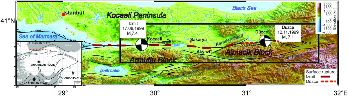
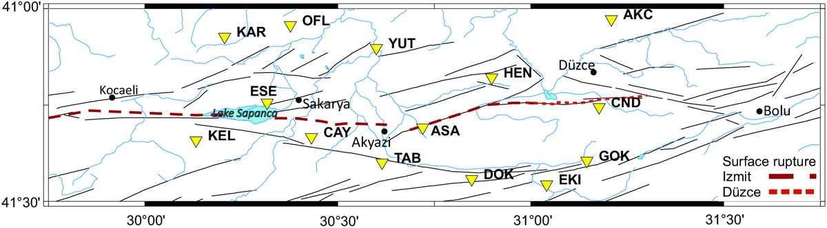
The complete network, consisted of 15 short period stations, covers an area of about 220 km by 70 km with an average spacing of 20km (Milkereit et al., 2000; Baumbach et al., 2003; Bindi et al., 2007).
SABONET was operated in event triggering mode during the time period considered here (1997-2001) except for the 2-month Izmit aftershock sequence when it was switched to continuous recording. Data processing steps and detailed characteristics of the SABONET hypocenter catalogue parameters containing ~10.000 events are given in Ickrath et al. (2015) and Bohnhoff et al. (2016b).
| Station ID | Latitude (N) | Longitude (E) | Elevation (m) |
AKC | 40.9723 | 31.2089 | 680 |
CAY | 40.6665 | 30.4315 | 291 |
| CND | 40.6665 | 31.1771 | 950 |
| CIN | 40.4360 | 30.3057 | 1100 |
DOK | 40.5579 | 30.8467 | 635 |
| EKI | 40.5440 | 31.0412 | 890 |
| GOK | 40.6052 | 31.1453 | 228 |
HEN | 40.6052 | 31.1453 | 590 |
KAR | 40.8214 | 30.8986 | 260 |
KEL | 40.6581 | 30.1328 | 1150 |
TAB | 40.6006 | 30.6147 | 400 |
YUT | 40.8978 | 30.6001 | 147 |
OFL | 40.9573 | 30.3771 | 350 |
ASA | 40.6915 | 30.7199 | 228 |
ESE | 40.7562 | 30.3167 | 374 |